
The Nazca Lines: Earth's Most Mysterious Ancient Geoglyphs
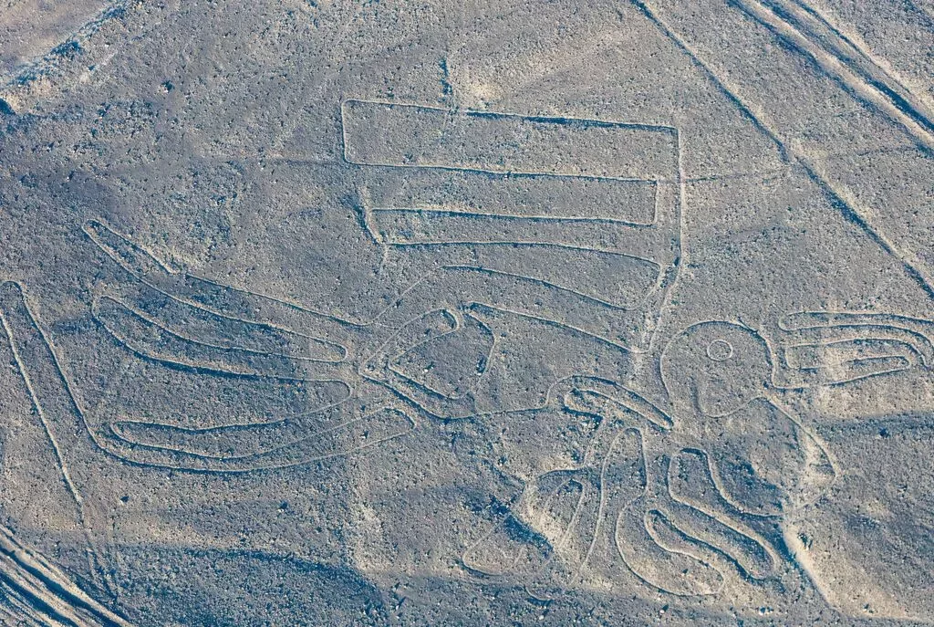
The Nazca Lines are one of ancient humanity's most intriguing enigmas: a series of geoglyphs cut into the stone plateau of the Pampa Colorada in southern Peru.
These enigmatic lines, figurative drawings, and geometric patterns, traced by the ancient Nazca culture between roughly 200 BCE and 650 CE, span more than 170 square miles (450 square kilometers) and make up the most impressive concentration of preserved geoglyphs anywhere on Earth.
The reason for their almost unbelievable preservation lies in the region's unique climate: average annual rainfall is under half an inch (10 millimeters), and a combination of high gypsum content in the soil, extreme dryness, and near-windless conditions at ground level has kept the figures largely unchanged for more than two millennia.
What gives the lines their special dimension is a paradox modern science still hasn't fully solved: many of the figures are visible only from the air, and can't be seen in their entirety from the ground.
The proportions are perfect, the lines are straight, the symmetry is precise, and all of it was achieved with no way to check the work from above.
That paradox continues to draw research teams from around the world, and every new discovery shows the site is far larger, richer, and more complex than anyone once assumed.
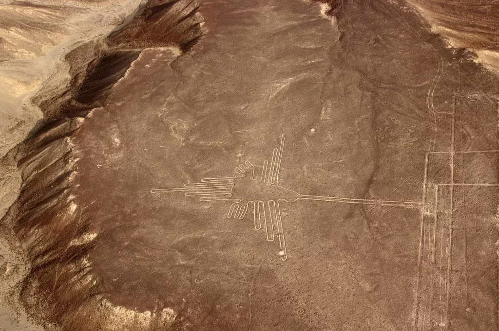
Photo: Monika Neumann, Pixabay
- 1.The Discovery of the Nazca Lines
- 2.What Are the Nazca Lines?
- 3.The Latest Discoveries: Yamagata University and a New Era of Research
- 4.The Role of Artificial Intelligence in Nazca Lines Research
- 5.Some of the Best-Known Theories About the Nazca Lines
- 6.The Nazca Lines Today: Protection and Threats
- 7.In Closing
The Discovery of the Nazca Lines
Toribio Mejía Xesspe and the Beginnings of Systematic Study
Although local residents and the occasional traveler had always noticed odd markings on the ground of the Pampa, the first systematic documentation of the Nazca Lines is credited to Peruvian archaeologist Toribio Mejía Xesspe, who began recording and describing the site in 1927.
Xesspe interpreted the lines as ceremonial roads, so-called ceques, meant for the ritual practices of the ancient culture.
His observations went largely unnoticed by the broader scientific community for years, and real scientific attention did not turn to the Nazca Lines until the following decade, when they were finally seen from above.
Aviation Opens a New Perspective
The real breakthrough in understanding the true scale of the phenomenon came with the growth of commercial aviation over Peru during the 1930s.
Pilots flying over the Pampa Colorada began reporting strange formations visible from above.
Photographs taken during these flights finally revealed the full scale of what lay below, and scientific interest in the site exploded.
Paul Kosok and the Astronomical Hypothesis
American professor Paul Kosok of Long Island University in New York initially studied the Nazca Lines mainly in the context of ancient irrigation systems.
But on June 22, 1941, while standing on one of the lines during the Southern Hemisphere's winter solstice, Kosok noticed something unexpected: the setting sun lined up perfectly with the direction of the line beneath his feet.
That chance moment completely changed the course of the research. From then on, Kosok began developing his theory about the lines' astronomical role, famously dubbing the vast desert expanse "the biggest astronomy book in the world," a phrase that has remained woven into the history of the site's study ever since.
Maria Reiche: Guardian of the Nazca Lines
What Kosok started, Maria Reiche (1903–1998) turned into her life's mission.
This German mathematician, who arrived in Peru in 1932, devoted a full forty years of her life to documenting, measuring, and protecting the Nazca Lines.
She developed a detailed thesis on the astronomical and calendrical purpose of the geoglyphs and selflessly advocated for the preservation of the site.
Unlike armchair researchers, Reiche lived in a small hut at the edge of the desert, personally keeping watch over the site and stopping vandals and careless visitors from doing damage.
Her work earned international recognition: in 1974 she received funding from the National Geographic Society, and the Peruvian government awarded her the Order of the Sun of Peru (Orden El Sol del Perú), the country's highest state honor.
Maria Reiche is remembered as the "Lady of the Lines" and one of the most dedicated scientists in the history of archaeology.
What Are the Nazca Lines?
Geography and Physical Features
The Nazca Lines sit on the Pampa Colorada, a flat, stony desert plateau in the Ica region of southern Peru, between the towns of Nazca and Palpa, at an elevation of roughly 1,300 feet (400 meters).
They were made using a simple but brilliantly effective technique: removing the dark red, oxidized stones from the surface of the ground to reveal the lighter, yellowish-gray soil underneath.
The contrast between the dark and light layers is what makes the figures visible, especially from the air.
The entire site was added to the UNESCO World Heritage List in 1994.
Three Categories of Geoglyphs
Researchers sort the Nazca geoglyphs into three main categories:
Lines and paths: More than 800 straight lines of varying lengths, some stretching as far as 30 miles (48 kilometers). Many stay geometrically precise without deviating even over long distances.
Geometric patterns: More than 300 geometric figures, including triangles, trapezoids, rectangles, spirals, and zigzag lines. Some of the trapezoidal areas are so large that a light aircraft could land on them.
Biomorphs (figurative geoglyphs): Depictions of living things: animals, plants, and humanoid figures, with some examples measuring as much as 1,200 feet (370 meters) across. Thanks to the latest research from Yamagata University, a total of 893 figurative geoglyphs had been cataloged by August 2025, many times more than anyone assumed just a few years earlier.
The Best-Known Geoglyphs
Among the most recognizable figures are:
- The Hummingbird: about 315 feet (96 meters) long, one of the most elegantly rendered figures and visible almost exclusively from the air
- The Monkey: about 360 feet (110 meters) long, known for its spiral tail
- The Spider: about 150 feet (46 meters) long, tied in local tradition to forecasting the rainy season
- The Condor: about 425 feet (130 meters) long
- The Orca (killer whale): symbolically linked to the water cult and ritual sacrifice in Nazca religion
- The "Astronaut": a humanoid figure on a hillside, nicknamed for its supposed resemblance to an astronaut in a spacesuit
Construction Technique: A Forgotten Simplicity
Experiments by modern archaeologists have shown that building the geoglyphs was entirely achievable with the tools available at the time.
Wooden stakes and rope, a basic surveying method, were used to draw straight lines over long distances.
Each figure could be drawn from a simple geometric template, gradually enlarged using a grid method.
Clearing the stones required no specialized tools, just organized, collective labor.
Estimates suggest a crew of a few dozen workers could have built even the largest geoglyphs in a matter of weeks to a few months.
The construction technique isn't the mystery. The mystery has always been why. That's exactly where the research saga that continues to this day begins.
The Latest Discoveries: Yamagata University and a New Era of Research
Japanese Researchers in the Field (2004–2022)
Japan's Yamagata University is one of the most active research centers studying the Nazca geoglyphs in the 21st century.
Led by Professor Masato Sakai, an archaeologist and anthropologist, the Japanese university's team has been working in the field since 2004 and has completely redefined our understanding of the geoglyphs' number, diversity, and origins.
Early discoveries laid the groundwork for what followed:
- 2011: The team discovered a geoglyph showing a figure with a severed head, measuring just 14 by 10 feet (4.2 by 3.1 meters), far smaller than any previously known figure and visible only from a drone.
- 2016: A figure about 100 feet (30 meters) long was discovered, depicting a mythical multi-legged creature; the construction technique points to the late Paracas period (400–200 BCE).
- 2018 and 2019: Combining fieldwork with artificial intelligence analysis, the Yamagata University team and IBM Japan announced the identification of 143 new geoglyphs. One of them, a humanoid figure about 16 feet (5 meters) tall holding a club-like object, was found solely thanks to pattern-recognition algorithms.
- December 2022: The team announced the discovery of 168 new geoglyphs in the Nazca region, documented through drone footage.
303 New Geoglyphs: A Historic Breakthrough Announced in 2024
In September 2024, the prestigious journal Proceedings of the National Academy of Sciences (PNAS) published the results of a joint project between Yamagata University and IBM Research (the Thomas J. Watson Research Center in Yorktown Heights, New York): fieldwork carried out between September 2022 and February 2023 confirmed 303 new figurative geoglyphs that had never before appeared in the scientific literature.
One number is enough to grasp the scale of this discovery: the previous hundred years of research had produced a total of 430 known figurative geoglyphs. A single six-month AI-assisted project nearly doubled that number.
The methodology was rigorous: an AI model, trained on all previously known geoglyphs, analyzed huge volumes of high-resolution aerial photographs and drone imagery.
The team then checked potential geoglyph locations on foot, putting in a total of 1,440 hours of fieldwork.
Of the 303 new geoglyphs, 178 were identified thanks to the AI model's recommendations, while 125 were found as additional discoveries during field visits to AI-flagged zones.
It's worth noting the team wasn't able to verify 968 additional AI-identified candidates during this phase of the research, meaning further discoveries are all but inevitable.
What the New Geoglyphs Reveal About the Purpose of the Nazca Lines
Beyond the sheer number, the 2024 PNAS study also delivered a key insight into the purpose of the geoglyphs.
An analysis of the placement and motifs of the 303 new figures, together with those already known, showed that the two types of geoglyphs differ significantly not just in style and size, but in function:
- Large line-type geoglyphs (mostly depicting wild animals) are arranged along a complex network of linear and trapezoidal shapes. They likely served community-level ritual activities: ceremonial gatherings, processions, or collective rites.
- Small relief-type geoglyphs (depicting humanoid figures, severed heads, and domestic animals) are positioned along winding paths, within view of passersby. According to the study's conclusions, they functioned as ritual markers or visual narratives for people making pilgrimages through the desert.
As Professor Sakai explains, Nazca society had no written language, so people learned about the roles of humans and animals from pictures, and used the sites themselves for ritual practice.
The orca, which consistently appears in Nazca ceramic iconography as a deity of rain and sea, is shown in the new geoglyphs in the context of human sacrifice, reinforcing the idea that these figures carry deep ritual meaning.
August 2025: The Discoveries Continue
In August 2025, Yamagata University announced the results of the next phase of research.
Field verification carried out during 2023 and 2024 confirmed 248 additional geoglyphs, 160 of them figurative.
With these discoveries, the total number of known figurative geoglyphs on the Nazca plain reached 893, more than four times what science knew just five years earlier.
The Role of Artificial Intelligence in Nazca Lines Research
The introduction of machine learning algorithms marked a new era in Nazca Lines research, one in which geoglyphs too faded, too small, or too visually subtle for the human eye can finally be detected.
IBM Research and Machine Learning
The AI program behind these historic discoveries was built by IBM Research scientists working with the Yamagata University team.
The model was trained on photographs of every previously known geoglyph.
Once trained, the system analyzed enormous volumes of aerial photographs and satellite images covering the entire Pampa, searching for visual patterns matching the characteristics of geoglyphs, even where outlines had nearly merged with the surrounding ground because of erosion and degradation.
AI's key advantage over the human eye lies in its ability to process enormous amounts of visual data without fatigue, detect subtle differences in soil density and texture, and eliminate the cognitive biases of a human observer.
Something an experienced archaeologist might miss simply because it doesn't match a preconceived pattern is exactly what the algorithm can detect without bias.
Speed as a New Advantage
Speed matters just as much as precision.
Johny Isla, Peru's lead archaeologist for the Nazca Lines, has stated that AI makes it possible to complete work that would take three to four years using traditional methods in just two to three days.
The 2024 PNAS study quantified this shift: AI sped up the rate of new discoveries by a factor of sixteen compared with non-AI methods.
These numbers carry one clear implication: the true number of geoglyphs on the Nazca plain still isn't known.
With 968 AI-identified candidate locations still awaiting field verification, coming decades of research will almost certainly bring a far more complete picture of the complexity of Nazca civilization, and perhaps, at last, of its purpose.
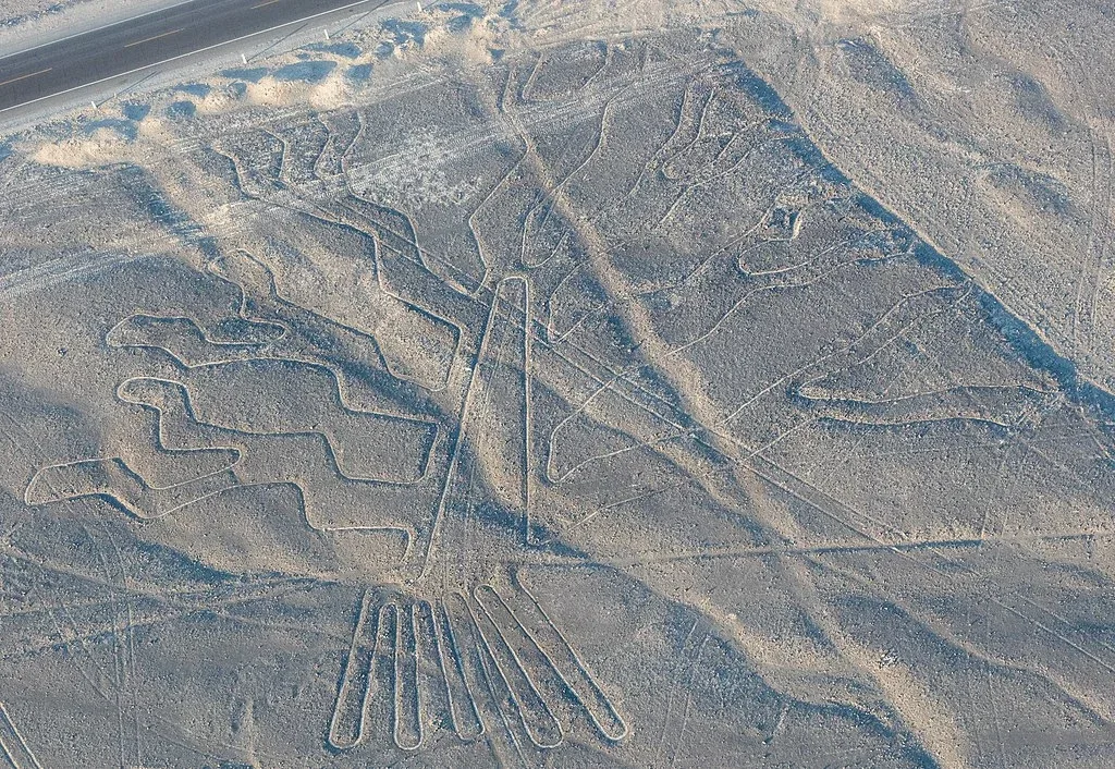
Photo: Diego Delso, CC BY-SA 4.0
Some of the Best-Known Theories About the Nazca Lines
The Nazca Lines have inspired a wide range of theories trying to explain their origin and purpose, from the scientifically grounded to the purely speculative. Here are the most influential.
The Ancient Astronaut Theory
Undoubtedly one of the most widespread, if scientifically unfounded, hypotheses about the origin of the Nazca Lines comes from Swiss author Erich von Däniken, who introduced it in his 1968 book "Chariots of the Gods?"
According to this theory, the straight lines on the Pampa Colorada were landing strips for alien spacecraft, and the geoglyphs were symbolic messages meant for beings from space whom the Nazca people supposedly worshipped as gods.
Von Däniken claims that extraterrestrials passed on knowledge and technology to the local population before leaving Earth, and that the lines are the supposed physical trace of that contact.
The theory became globally known through the documentary series Ancient Aliens (History Channel), and in 2018 a new wave of interest was sparked by photos of geoglyphs that resembled the stereotypical image of aliens with large black eyes.
Scientific criticism of the theory, however, is consistent and clear: the lines aren't flat or firm enough for any kind of landing, there's no physical evidence of extraterrestrial contact, and the premise itself implies, wrongly and deeply offensively, that ancient peoples couldn't have achieved this without outside help.
The Hot-Air Balloon Theory
American researcher Jim Woodman put forward a theory during the 1970s that the Nazca people had the ability to fly in hot-air balloons made from local materials.
The argument was that the lines could only have been drawn with a view from above.
In 1975, Woodman and British balloonist Julian Nott built an experimental balloon, named "Condor I," using fabrics and materials that could have been available to the Nazca people.
The balloon got airborne, but the flight lasted only a few minutes.
Woodman's claim that he had found a pottery fragment depicting a balloon was never confirmed by independent expert verification.
There is no archaeological evidence confirming the existence of balloon technology in Nazca culture, and modern experimental archaeology has clearly demonstrated that the geoglyphs' geometric precision can be achieved using ground-based techniques alone.
A Giant Solar Calendar
Maria Reiche's theory remains one of the most seriously considered in academic circles.
Reiche argued that the Nazca Lines and geoglyphs form a complex astronomical and calendrical system, with individual lines aligned to the rising and setting of the sun, moon, and certain stars at key moments in the calendar cycle: solstices, equinoxes, and the start of the rainy season.
Some of the lines are indeed aligned with astronomical events, and it's well known that many ancient cultures built their monuments with astronomical orientation in mind.
However, American astronomer Gerald Hawkins carried out a statistical analysis of the lines' orientations in the late 1960s and early 1970s and concluded that the astronomical alignments were no more significant than would be expected from random chance.
Reiche rejected that criticism for the rest of her life, and the debate between the two positions remains open.
The Eye From the Sky
Independent researcher Robin Edgar proposed a variant of the astronomical theory holding that the Nazca Lines and geoglyphs were made to be seen by a "divine eye in the sky," the dark sun ringed by a brilliant corona during total solar eclipses.
In this interpretation, the geoglyphs would have been votive offerings or a form of direct communication with celestial deities in the rare moments when the "divine eye" opens above the desert.
Edgar's theory doesn't have broad support in academic circles, but it offers an intriguing framework for understanding the ritual dimension of the lines.
Underground Aqueducts (Puquios) and Water Rituals
One of the most scientifically well-supported theories in current archaeological literature concerns the connection between the Nazca Lines and a water cult in this extremely arid desert.
In a region that receives less than half an inch (10 millimeters) of rain a year, access to water wasn't a matter of comfort. It was a matter of survival.
This theory rests on one of the most overlooked, and most impressive, engineering achievements of Nazca culture: a network of underground filtration galleries known as puquios.
A total of 36 documented underground channels running through the Nazca and Palpa region worked by capturing groundwater through spiral surface openings called ojos, Spanish for "eyes."
Wind entering the spiral creates pressure that pushes water through underground channels to surface reservoirs, a mechanism that works on pure physics without any moving parts.
An Italian-Peruvian research team led by Rosa Lasaponara of Italy's National Research Council (CNR) published a 2016 study in the book The Ancient Nasca World (Springer), concluding that the puquios were active throughout the entire span of Nazca culture and that signs point to additional, still-undiscovered underground channels.
Researcher Johan Reinhard, who spent years documenting mountain shrines and Nazca culture, has argued that both the geometric lines and the animal figures are part of a broader system of ritual processions tied to prayers for rain and fertile soil.
The trapezoidal plazas and long lines could have functioned as ceremonial routes along which groups made pilgrimages to ritually significant places: water sources, sacrificial sites, and ceremonial centers such as the great Nazca center of Cahuachi.
This interpretation is backed by the iconography: the orca consistently appears in Nazca pottery tradition as a deity of rain and sea, and the latest analysis from the 2024 PNAS study shows the same motifs present in the newly discovered small geoglyphs located along processional routes.
According to local tradition, the spider was a symbol tied to forecasting the rainy season.
These iconographic parallels strongly suggest that water, fertility, and renewal were central themes of Nazca spiritual and religious life, and that the lines were the physical expression of those beliefs, traced directly into the desert floor.
The Nazca Lines Today: Protection and Threats
UNESCO Protection and Challenges on the Ground
The Nazca Lines have nominally been protected as a UNESCO World Heritage site since 1994, but real-world protection of the site faces ongoing challenges:
- Erosion and climate change: Extreme rainfall events, growing more frequent because of climate change, can cause irreversible damage to the thin lines.
- Vandalism and uncontrolled tourism: Careless visitors who step off the marked paths leave permanent marks on the fragile ground. A dramatic example happened in December 2014, when Greenpeace activists, during the UN's COP20 climate conference in Lima, entered a restricted area next to the Hummingbird geoglyph without authorization and left visible, permanent marks in the soil.
- Urbanization: The growth of the towns of Nazca and Palpa, along with nearby infrastructure projects, puts long-term pressure on the site.
- Illegal dumping: Multiple cases of illegal waste dumping degrading the terrain have been documented around the edges of the UNESCO-protected zone.
International Scientific Cooperation and a Digital Future
Alongside Yamagata University, which leads the most extensive documentation and analysis program, teams from Italy, Germany, the United States, and Peru are actively working on the Nazca Lines. The Maria Reiche Association continues its work promoting and protecting the site.
A high-resolution 3D digital reconstruction project for the entire site, led by international research institutions, should give scientists a complete digital replica of the Pampa Colorada in the coming years, without the need for further physical intervention on the ground.
Combined with AI detection and satellite data, this digital infrastructure could finally answer the question humanity has been asking itself for a hundred years.
In Closing
A hundred years of research have raised far more questions than answers, but at least one question is finally closer to being resolved: the Nazca Lines weren't created from a single impulse or for a single purpose.
This is a layered cultural phenomenon built up over centuries, woven through with processions, rituals, water cults, storytelling without writing, and communication with something beyond the everyday horizon.
Artificial intelligence has shown us that we only knew a small part of the story.
When Paul Kosok looked up at the setting sun in 1941 and noticed it lined up perfectly with the line beneath his feet, he had no way of knowing that, eight decades later, algorithms would process millions of images to reveal another 893 figures that humanity had been waiting all along to notice.
With 968 AI-identified candidate sites still awaiting field verification, the final number of geoglyphs remains unknown.
The Pampa Colorada guards its secrets patiently. We've simply learned to search more cleverly.
Cover image: Diego Delso, CC BY-SA 4.0, via Wikimedia Commons
SOURCES
- Sakai, M., Sakurai, A., Lu, S., Olano, J., Albrecht, C. M., Hamann, H. F., & Freitag, M. (2024). "AI-accelerated Nazca survey nearly doubles the number of known figurative geoglyphs and sheds light on their purpose." Proceedings of the National Academy of Sciences, 121(40), e2407652121.
- Sakai, M., Lai, Y., Olano Canales, J., Hayashi, M., & Nomura, K. (2023). "Accelerating the discovery of new Nasca geoglyphs using deep learning." Journal of Archaeological Science.
- Yamagata University (2024). "AI-accelerated Nazca survey nearly doubles the number of known figurative geoglyphs and sheds light on their purpose." Press release, September 24, 2024.
- Yamagata University (2019). "143 New Geoglyphs Discovered on the Nasca Pampa and Surrounding Area." Press release, November 15, 2019.
- Agencia Andina (2025). "Líneas de Nasca: hallan 248 nuevos geoglifos en Ica gracias a la inteligencia artificial." Peruvian state news agency, August 5, 2025.
- Lasaponara, R., Lancho Rojas, J., & Masini, N. (2016). "Puquios: The Nasca Response to Water Shortage." In The Ancient Nasca World. Springer.
- Schreiber, K. J., & Lancho Rojas, J. (1995). "The Puquios of Nasca." Latin American Antiquity.
- Silverman, H., & Browne, D. (1991). "New evidence for the date of the Nazca lines." Antiquity, 65(247), 208–220.
- Hawkins, G. S. (1974). "Astronomical alinements in Britain, Egypt and Peru." Philosophical Transactions of the Royal Society A, 276(1257).
- Masini, N., & Lasaponara, R. (2020). "Satellite and close range analysis for the surveillance and knowledge improvement of the Nasca geoglyphs." Remote Sensing of Environment.
- Mejía Xesspe, T. (1939). "Acueductos y caminos antiguos de la hoya del Río Grande de Nazca." Actas y Trabajos Científicos del 27 Congreso Internacional de Americanistas, 1, 559–569.
- UNESCO World Heritage Centre. "Lines and Geoglyphs of Nasca and Palpa." World Heritage List, ref. 700, inscribed 1994.
- von Däniken, E. (1968). Chariots of the Gods? Unsolved Mysteries of the Past.
Aron Corvin
A researcher of the unknown who loves a good story. I won't sell you sensationalism just for a click. If you enjoy what I write, your support would mean a lot and help me keep going.